Overview
The Sandover Highway is an outback unsealed track in the Northern Territory between the Plenty Highway north of Alice Springs and the Northern Territory/Queensland border.
.jpg)
Description
The western approach to the Sandover Highway is easily found after a straightforward bitumen drive north-east from Alice Springs, but
the eastern approach resembles navigating upstream in a river delta.
Property access roads from Camooweal, Mt Isa, and Boulia lead to Lake Nash, which is the eastern end of the Sandover Highway.
Our suggested west-running route starts in Winton and takes in some scenery and points of interest that shouldn’t be missed. Lark Quarry is a must-visit site that’s an easy gravel and bitumen road drive from Winton.
From Lark Quarry, our route heads west, for Old Cork Station, on the Diamantina River. This abandoned house was constructed at great expense by Sir Thomas McIlwraith – later three times premier of Queensland – in 1875. The site is decaying rapidly and is in need of urgent restorative work. It is magnificent
river-bank camping at Old Cork.
Our route continues west, through the supply points of Boulia and Dajarra, to Urandangi. The road crosses black soil plains and numerous channels, with
low mesa-topped ranges in the distance.
Urandangi has had its ups and downs in recent years but has now entered a purple patch. Known as the Dangi Bush Resort the pub has free showers and camping in a grassed area, beside a dam at the back of the pub.
For those who want a rest from camping, there’s a choice of three well-furnished rooms – two doubles and a single – of a central dining area.
The dining room doubles as an art gallery where local Aboriginal artists sell their wares. We bought one of Abie Loy’s beautiful paintings for much less than we’d have paid in the Big Smoke.
The Dangi Pub is now at its pristine best – no more dogs in the bar – and there’s no disorder allowed. Families are more than welcome and petrol and diesel are available.
The track to Lake Nash heads north-west through Headingly Station and topographic maps are essential for this route because there are no reliable road signs.
We went through there after flooding and much of the track was washed away, making for interesting navigation and driving challenges! If you’re towing a camper van or off-road caravan it’s best to reach Lake Nash via the property roads from Camooweal.
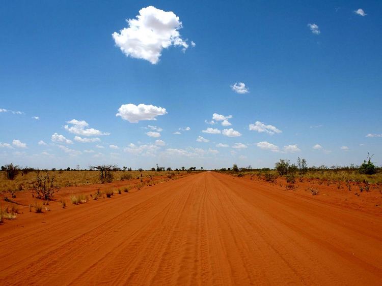
More than a million dollars has been spent on the Sandover Highway since 2007 and it shows in brand new sections along the route. Near Lake Nash, it’s a broad expanse of gravel but soon alternates between that extreme and a two-tire track through soft sand. High ground clearance is essential for The
Sandover.
The road passes through arid country for its full length, with variations between grassland, open mulga woodland, and spinifex desert. Where the road crosses the Sandover River the vegetation improves and there are creek-bank stands of tall eucalypts.
No rest or overnight camping areas are shown on most maps, but there are three of them and all have water tanks and shelters: one is about 30km west of Lake Nash; another is opposite Ammaroo Station and the third is east of the Mt Skinner Station turnoffs.
Arlparra Store lies approximately 28km inside the boundary of Urapuntja, which is an area formerly known as Utopia Station. It’s the major center for a number of Aboriginal communities in the area. Fuel and food are obtainable from Arlparra which is open weekdays, 9 am-5 pm and Saturday, 9 am-12 pm. Emergency
medical facilities are available at the administrative center of Urapuntja.
There’s
nothing much in the way off off-track excursions along the Sandover Highway, because it’s mainly pastoral and Aboriginal land. However, it’s possible
to do a part-Sandover and turn off to the north at Amaroo and join the Binns Track that runs through the Davenport Ranges and emerges onto the Stuart Highway near the Devils Marbles.
From Urandangi to Alice Springs is 750km of mainly dirt road driving, so fuel consumption is heavier than bitumen road driving. If you’re traveling in a vehicle with a standard fuel tank it would be wise to fuel up wherever possible: Urandangi, Lake Nash, and Arlparra, but fuel isn’t always available at Lake Nash.
From Alice Springs to Arlparra is 310km and from Arlparra to Lake Nash is 340km. Lake Nash to Urandangi is 100km.
Sandover Northern Territory
Australia
URL:
http://outbacktravelaustralia.com.au/destinations-travel-destinations/sandover-and-plenty-highways/